
A few weeks ago, I did a little write-up of the first two “sections” of the PCT, what I expect to see, how long each is, what I’m excited nervous about, etc. In this post, I’m going to finish that up and talk about the final three sections of the hike: Northern California, Oregon, and Washington.
For reference, here’s that map I’ve put up a couple of times already.

Northern California
Starting Point: Sonora Pass (End of CA Section I)
End Point: CA-OR state line
Distance: 680 miles
Most excited about: (at least within 100 miles of Lake Tahoe) being in very familiar territory, being able to catch some friends for short stretches.
Most nervous about: The more northern part of the section, where I’m no longer close to home, and still have half the trail left to do.
The Norcal section of the trail starts in the Northern Sierra Nevada, and is defined at first by the gradual softening of the geography, as the rugged High Sierra gives way to lower canyons replete with roads and (some form of) civilization.
For most people, this section (as well as Oregon) is the least popular, and can be a bit of a letdown after the epic High Sierra and the really unique desert sections.
I know I won’t be in that camp, at least for the first couple hundred miles. The Northern Sierras are sort of home to me, having spent a whole lot of time growing up at the summer resort my extended family operates in Sierra County called Salmon Lake Lodge (in Section M above). Growing up in Davis (near Sacramento), it was also about a 2-hour drive to the Lake Tahoe region, so I’ve spent a lot of time around there with various family and friends. So I’m very excited to be in familiar territory at the halfway point of the hike.
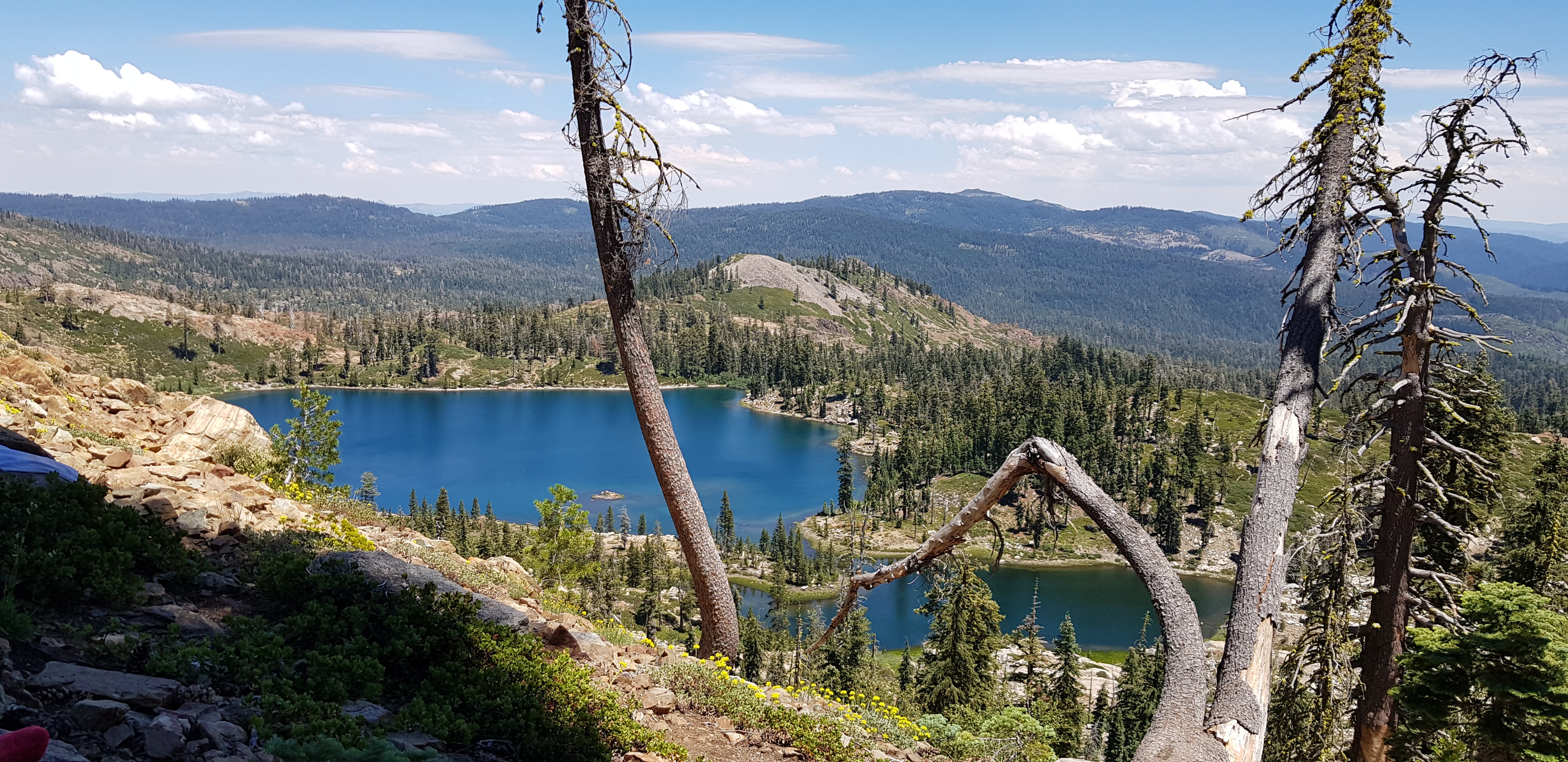
Deer Lake, just above Salmon Lake, from a hike last summer
It’s going to be really tough to leave Salmon Lake though, as that marks the last and most familiar spot for me in this section, and it’s not even the halfway point of the trail.
Not only will that mark the end of familiar ground to me, the hiking also gets more annoying: In the higher sections of the trail, the big climbs are to get over high mountain passes, and you’re rewarded with great views and a sense of accomplishment. In Northern California, the big climbs are quite often out of a low canyon, probably fully loaded from a resupply in the town that’s on the river, and you don’t get the same sense of accomplishment. There’s also a step down in the sense of isolation, with a lot more evidence of human habitation, logging, etc.
Still though, I think hiking the whole length of California is pretty neat, so the push to the Oregon state line will be exciting.
Oregon
Starting Point: CA-OR state line
End Point: OR-WA state line
Distance: 456 miles
Most excited about: Everclear is legal, representing the most booze you can get for the least weight.
Most nervous about: Generally the least popular section of the trail. It’s far enough in that I’m unlikely to be still giddy about hiking, but too far from the end for the finish line to be in view.
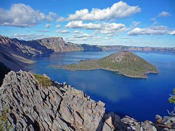
Oregon is a very lovely state, and in my experience, Oregonians are a fiercely proud people. However, the trail through Oregon is generally regarded to be a necessary and uninspiring obstacle on the way to the much more popular Washington. While Oregon is home to several major Cascade volcanoes (Mt Hood, Mt Jefferson, Three Sisters, Crater Lake), the trail generally goes around rather than up these features (except for Crater Lake, which is one of the world’s most beautiful places). Instead, the trail is mostly flat and wooded, so not a lot of great views. Surprisingly, there are also a few noteworthy dry stretches.
Thus, with the uninspiring scenery, the flat terrain, and the fast-approaching Canadian winter, the name of the game is to rack up mileage. There are two distance challenges that hikers often partake in: the 10-day 300-mile challenge, and the two-week all-of-Oregon challenge (the latter is a bit more difficult).
Some upsides to Oregon, though: Everclear (95% grain alcohol) is legal, and it might just be weight-efficient enough to be the only time I’ll carry alcohol with me on the trail (obviously excepting champagne and/or whiskey for the finish).
Also I’ve got some friends in Bend and Portland (including Meeza, the designer of my logo, whose wedding I’m missing to be on the trail), and it’ll be nice to briefly catch up with them.
Washington
Starting Point: OR-WA state line
End Point: US-Canada border (+9 miles into British Columbia to the nearest road)
Distance: 505 miles to official northern terminus, 514 miles to end of the hike.
Most excited about: Return to stunning, glaciated scenery.
Most nervous about: Beating the winter; returning to the real world 😦
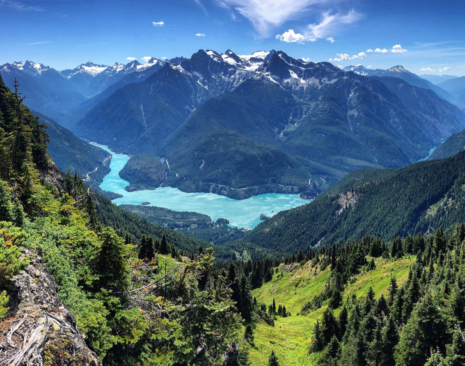
The final section of the trail is the state of Washington, generally regarded to be the second best section of trail (after the high Sierras). Like Oregon, Washington is in the Cascade range, defined largely by volcanoes. The volcanoes are somewhat larger (like Mt Rainier, which is an awesome peak), and the terrain outside of the volcanoes is much more rugged, largely having been carved by glaciers in past ice ages.

Hopefully I’ll have made good time in Northern California and Oregon, because I’d love to take it a little slower in Washington and appreciate the final weeks on the trail. However, the first snows usually hit in early October, and in the interest in avoiding a Donner Party-type situation (unlikely to be effective, given how emaciated most of us will be), I’ll need to blast through it if I start the section later than early-mid September.
The official northern terminus of the PCT lies in a clearing of trees at the border with Canada. Like with any finish line (whether literal, like the end of a race, or metaphorical, like a graduation), I’m looking forward to celebrating, but am also nervous about returning to civilization. Post-hike depression is a real thing, and I’ve struggled with similar finish-line-type life changes before.
And that takes us to the end of the (preview of the) hike! Can’t wait to re-do all of this in real time as I hike it!
Potential future posts (in the two months remaining before I hit the trail): How I define success and failure (and coming to terms with the possibility of failure); Why the hell am I doing any of this?; What am I bringing with me on the trail?
